|
W W W . S A
N D R U N N E R . C O M |
|
UTAH |
|
|
| GLAMIS |
DUMONT |
ST.
ANTHONY |
OREGON |
PISMO
BEACH |
MEXICO |
|
|
|
|
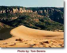
Coral
Pink Sand Dunes State Park
|
|
Pinkish
sand worn from surrounding cliffs and carried by the
wind have created over 3,000 acres of sand dunes, some
several hundred feet high, in the distinctive Coral Pink
Sand Dunes State Park. You can explore the dunes on foot
or cruise them on dune buggies, all-terrain vehicles and
motorcycles. The park is especially attractive at dawn
and dusk as the light and shadow accentuate the color of
the sand. |
| The area is
a rather distinct ecosystem. The
park's sand dunes are created because a notch between
the Moquith and Moccasin mountains funnels the
prevailing winds, increasing their velocity to a point
where they can carry sand grains in what is called the
Venturi Effect. Eroding Navajo Sandstone formations
surrounding the park and the
presence of iron oxide in the sand account
for the unique color of these dunes.
|
|
|
|
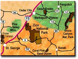
The
Coral Pink Sand Dunes are located about 27 miles
northwest of Kanab, Utah, along the Arizona border
towards the southwest corner of Utah. The entire Coral
Pink Sand Dune area is approximately 3,500 acres. The
northern part of the dunes (approximately 1,500 acres)
is managed by the BLM and is included in the Moquith
Mountain WSA. The southern portion (approximately 2,000
acres) is located in the Coral Pink Sand Dunes State
Park. The park is located 20 miles west of Kanab and 40
miles southeast of Zion National Park.
You can contact the park at:
The Coral Pink Sand Dunes
Box 95, Kanab, UT 84741; 435-648-2800

Powered by Addresses.com Weather |
|
|
|
|
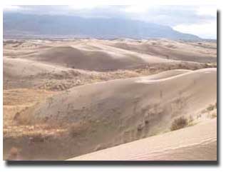 |
The
Little Sahara sand dunes, located in the northeastern
part of the Sevier Desert in western Utah, lie within
the northern half of one of Utah’s largest dune fields
(about 220 square miles). These rolling dunes are
comprised of free-moving sand dunes, sagebrush
flats, and juniper-covered hills. Elevation 5000
- 5400 feet. Administered by the Bureau of Land
Management, Little Sahara Recreation Area is mostly
devoted to off-road vehicle use. Campgrounds can
be found at Jericho, Sand Mountain, Oasis, and White
Sands. Group camping is available at Sand Mountain.
There is a daily use fee. Annual permits are also
available.
Sand
dunes on the east side of Little Sahara Recreation Area.
Gilson Mountains in background. |
|
|
How to get there: The Little
Sahara Recreation Area is about 110 miles from Salt Lake
City via Nephi. Travel on I-15 to Nephi. Take exit 225
and travel west 14.5 miles on State Route 132 to Juab
County Route 1812 (“Sand Dunes” sign). Turn right
(northwest) onto Route 1812, travel about 14 miles,
passing through Jericho Junction (intersection with U.S.
Highway 6), until you reach the turnoff sign for Little
Sahara Recreation Area. Turn left (southwest) to enter
the area.
Pictures
of Little Sahara. |
|

|
Bureau of Land Management
Fillmore Field Office
Bureau of Land Management
35 East 500 North
Fillmore, UT 84631
Phone: 435-743-3100
Email: SMaurer@plia.org |
Visitor
Center Office: 435-433-5960
Weather Information: 435-433-5961
Little Sahara Brochure (PDF) |

Powered by Addresses.com Weather
|
|
|
|
|
|
|
|
|
|
|
|
|
|
|
|
|
|
|
|
|
|
|
|
|
|
|
|
|
|
|
|
|
|
|
|
|
|
|
|
|
|
|
|
|
|
|
|
|
|